Friday, February 29, 2008

lamp post at the port


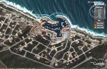
Puffy clouds and a lamp post on the paving in front of the restaurants at the edge of the yacht basin...... a great place to sit with a cold drink after a warm day and watch the sun go down.

Thursday, February 28, 2008

Kromme River


Just before you get to St Francis Bay, you cross the Kromme River and get a beautiful view of the river and adjacent wetlands. The river has become a popular holiday area, with many new built homes along the river bank. The white buildings in the distance are the houses on the canals, at the river mouth.

Wednesday, February 27, 2008

Shipwreck


There are quite a few shipwrecks along this trecherous part of the coast, where a reef runs 10km out to sea beyond Seal Point, and gales that had their birth in the Antarctic can sweep past with surprising fierceness. This is part of the remains of the President Steyn, which ran aground next to the lighthouse at Seal Point. It is hard to spot, as it is so eroded, and only visible at very low tide, but has a strange beauty of its own.

Tuesday, February 26, 2008

Wild Seas


One of my favourite photos taken the morning after the storm, shown in yesterday's movie post, is this one of the waves pounding the beach. It was September 2006.

Monday, February 25, 2008

Anyone care to go to the movies?

Today, instead of a photo, we are posting a movie that we put together. It is a combination of video and stills captured on the beach at sunrise after a big storm and Spring Tide. It was wild and windy, so there are times when the image stabilizer couldn't cope, but we hope the movie can convey to you how invigorating and stunning it was on the beach that morning. The background music is 'why worry' by Dire Straits.... which pretty much sums up St Francis, who can worry for long in such surroundings?!!

Sunday, February 24, 2008

Tsitsikamma River Mouth #2


Another view of the rugged part of the coast, its jagged dark rocks contrasting with the soft pastel shades of sea and coastline.

Saturday, February 23, 2008

Tsitsikamma River Mouth


Yesterday we showed you a view looking Westwards from Seal Point, and told you about Thyspunt. 25km along the coast from St Francis is the mouth of the Tsitsikamma river, a wonderful wild inaccesible spot. Well, except for 4x4s that is. This compacting of the delicate coastal dune ecosystem is a perfect example of why our Department of Environmental Affairs has clamped down on vehicles on beaches. To the left as we look at this picture, there is a fascinating cave which the sea rushes through, which we will show you soon.

Friday, February 22, 2008

Imagine a nuclear power station here....


This is the view from the 'wild side', near the lighthouse, looking up the coast towards the west, and the second peninsula is Thyspunt. It is about 12 km from St Francis, and has been earmarked for construction of a Nuclear Power plant, despite vigorous public opposition.


There is a farcical pretense that a process of consultation is taking place, but it is apparent that in reality, the decision to build an experimental pebble bed Nuclear reactor at Thyspunt is being steamrolled through. This is due to the power crisis that has been precipitated by the complete ineptitude of the powers that be.


Naturally a nuclear power plant so close to a prime built up area is cause for great concern, but there are many vested interests behind the scenes in this project, as both USA and Japan want a chance to test this technology, but are unable to do so on their own territory, so they have made it worth the while for our Government to push it through. I just wonder if the country as a whole will benefit, or if it will be the usual scenario of one or two key individuals having newly bulging bank accounts?

Thursday, February 21, 2008

Looking up

A different view of the Lighthouse at Seal Point, built in 1878.


Bonus behind the scenes shot:
Our grandson looks on in amazement as granny lies on the ground in the doorway to get the angle she is after, while his parents pretend they don't know this person, and wish they were somewhere else !

Wednesday, February 20, 2008

Wave watching


We love sitting watching the waves smashing on the rocks near the lighthouse, and on a windy day when the water is whipped back again, it is even better! A group of Cape Gannets does a fly-by and gets a birds eye view.

Tuesday, February 19, 2008

lighting up our lives


Not sure if this is a rainbow, or just the base of the clouds refracing light, but either way it is a cool backdrop for the lighthouse!

Monday, February 18, 2008

Alien sunset

As with many places along South African coast, the Cape St Francis area was characterised by large dune fields. When it was first developed as a tourist area, the large amounts of sand that were blown by the wind made life quite unpleasant at times. It was decided to stabilise the dunes by planting port Jackson Willows from Australia.

The alien vegetation flourished and did its "job" very effetively, but at a cost. It has totally smothered much of the unique indigenous vegetation of the area, it has become a major fire hazard and has also reduced the level of the water table.


This sunset photo was taken shortly after a fire had swept through the area last year and the stark trees serve as a reminder of the constant threat of devastating fires. The alien invaders burn much hotter and faster than the indigenous vegetation and as a result also destroy a lot of wildlife that would otherwise have survived.


Major projects are now underway to remove the alien invaders. The moral of the story is don't mess with nature.

Lighthouse

View of the lighthouse at seal point.


Saturday, February 16, 2008

Wave over Sunset


This is one of my favourite photos that we have taken at St Francis over the years. We sat on the rocks at the 'wild side', beyond the lighthouse, and watched the waves pounding on the rocks as the sun went down.

Friday, February 15, 2008

Cape St Francis Sunrise


The wide sweep of pristine beach, lit by the sun rising over Shark Point. Paradise on earth!

Thursday, February 14, 2008

Coastal Erosion

Since we discussed coastal erosion on the PE blog today, and St Francis is in the midst of a bit of a crisis because of this, we thought it apt to feature it here too. This shot was taken in January 2007, from the beach car park at St Francis Bay. Since then it has got worse, and in a recent storm, some of the roads leading to the beachfront properties were washed away, as well as the ablution block here and the foundations of some houses are beginning to be undemined.

When we went there for the first time in the mid 90s, we went for a walk along the 2 km wide sandy beach all the way to the Kromme River Mouth and back. Now it is impassable in many places, as the sand has been eroded away by currents, and due to the development and cutting off of the migratory sand river dunes from the rest of the coast, it is not being replaced. All sorts of expensive and controversial plans have been put forward to fix it, but as there are not enough funds, nothing has been done. At last, there may be light at the end of the tunnel, and a cost effective scheme which has been successful along the North Sea coast is being looked at. Let's hope something comes of it soon, as this situation can't be left to continue as it is for much longer.

Wednesday, February 13, 2008

Beach Cottage


This beach house is wonderfully positioned on a rise overlooking the surf spot at Seal Point. I adore the Cape Cod architecture, and the way the colours were so cleverly selected to blend with the surroundings. On this rainy day it has a lonely look about it that is very reminiscent of some of Andrew Wyeth's paintings.

Tuesday, February 12, 2008

spring tide #5 After the storm


The sun rises on a beautiful new day. The swells are high but the storm has passed.

Monday, February 11, 2008

spring tide # 4


Riding out the storm

The day before the spring high, a storm came through, and the bay was just crammed with fishing boats who had come into the relatively sheltered spot to ride out the storm. If you look at the big map on the sidebar, the westerly winds go tearing past shark point and across the bay, leaving a sheltered spot near the harbour mouth. Beyond the point there was a visible difference in the sea and the swells were huge.

Sunday, February 10, 2008

Spring Tide #3 Pounding the Breakwater

on a normal day


spring high

Here you see the harbour wall that we posted 2 days ago, being pounded by waves at Spring High, this time from the outside of the wall.

By the way, if you followed the drive we did down the Elands River Valley last week on the Port Elizabeth Daily Photo, and on our personal blogs, the mountains in the background that you see here are part of the Winterhoek Mountain Range that we were travelling through on that trip.

And if you are interested in how this breakwater is constructed to withstand these assaults from the sea, I did a post on the dolosse here.

Saturday, February 9, 2008

Spring Tide #2

Yesterday we spoke about the effect of spring tides at the Port. Here is a series taken the day before the spring tide. It was not at the extreme high and low because low was about 2 hours after the first set was taken, but even so you can see how much the water level changed in the yacht basin.


Friday, February 8, 2008

Spring Tide #1

Last March, St Francis experienced a combination of Spring Tide and a severe storm. It was great watching the wild seas. It is the fullest we have ever seen the port, as all the fishing boats huddled together for shelter. The following morning was misty and an eerie post-storm calm settled over the bay. In the next few days we'll show you some of the pictures from that weekend.

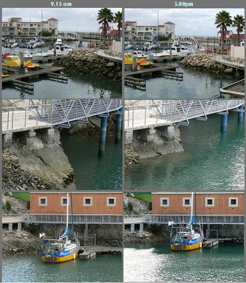
The waves were so huge that they were breaking right over the harbour wall, too forcefully to walk there. It is hard to give you a idea of how large they were, but the wall on the right is too high for even a tall person to look over, and normally there is still about the equivalent of 3 stories of breakwater below the wall on the outside.

Thursday, February 7, 2008

A different kind of road....


Since we are talking about roads on the PE blog today, I thought it would be an idea to do the same here. This sign is on the road to the Seal Point Lighthouse. The R5 coin is about 30mm in diameter. The "Kimberley se gat" is a colloquial reference to the great hole of Kimberley, an enormous abandoned diamond mine.


What they fail to mention is certain other less cute creatures that can be found there, like this mean looking Puffadder! Most snakes will get out of your way if they hear you coming, but Puffadders are lazy and would rather wait till you are close enough to bite, so you have to be very alert when walking through the bush, and particularly in dead leaves, where they are very hard to spot.

Wednesday, February 6, 2008

rusty bits


When the breakwater for the harbour wall was constructed at the Port, tons of rocks that had been blasted from the yacht basin were moved to build it up. To make it easier to move these huge rocks, large metal hooks were drilled into them, so that they could be picked up by cranes. These have now rusted to become a picturesque part of the breakwater.

Tuesday, February 5, 2008

In the spotlight


A seagull on the harbour wall is highlighted by the rising sun. I loved Clarice's comment the other day that in St Malo they call them Rats with wings!

Monday, February 4, 2008

Farol... a great place to eat


One of the restaurants we really enjoy in the village is Farol. It isn't especially fancy (maybe that's one reason we feel at home there!) but it is well designed, and the food is always good. The service is friendly and personal, the owners are always there taking an interest in the patrons and making sure you are happy. Their fresh fish and steak espatade are drool worthy!

Sunday, February 3, 2008

the village


The village of St francis Bay stands on land that was bought in 1954, by Leighton Hulett who moved from Zululand with his wife and children. Initially it was set up as a fishing camp where he and his family and friends enjoyed bathing and fishing in this isolated paradise. A small township of 51 plots was laid out in 1956 and at that stage it was still going to be called Cape St Francis. This name was first changed to Sea Vista in 1960. After the establishment of the first approved township Hulett developed the marina glades, the town grew and after a public referendum in 1979 the village name was officially changed to St Francis Bay. His insistence on a specific style of architecture, preserving character, ensured the development of a village that is quite unique.

Saturday, February 2, 2008

coming in to land


It is hard to imagine any seaside resort without the distinctive cry of seagulls in the air.... St Francis is no exception!

Friday, February 1, 2008

February Theme Day: When people think of St Francis they think of...

The distinctive thatched houses with white walls, basking in the sun. Laid back holidays, fishing, surfing and enjoying the relaxed atmosphere surrounded by blue sea.
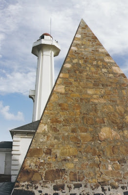
Many other City Daily Photo Blogs around the world are also participating in this theme, pop in and pay them a visit.

Portland (OR), USA - Menton, France - Monte Carlo, Monaco - Memphis (Tennessee), USA - Manila, Philippines - San Diego (CA), USA - Anderson (SC), USA - New York City (NY), USA - San Diego (CA), USA - Mexico City, Mexico - San Francisco (CA), USA - Mumbai (Maharashtra), India - Mainz, Germany - Weston (FL), USA - Minneapolis (MN), USA - Turin, Italy - Las Vegas (NV), USA - Hobart (Tasmania), Australia - Bicheno, Australia - Durban, South Africa - Joplin (MO), USA - Nashville (TN), USA - Stockholm, Sweden - Kyoto, Japan - Tokyo, Japan - Brussels, Belgium - Chicago (IL), USA - Montpellier, France - Seattle (WA), USA - Mazatlan, Mexico - Saint Paul (MN), USA - Sharon (CT), USA - Sesimbra, Portugal - Toulouse, France - Tuzla, Bosnia and Herzegovina - Susanville (CA), USA - Maple Ridge (BC), Canada - Saint Louis (MO), USA - Prague, Czech Republic - Helsinki, Finland - Pilisvörösvár, Hungary - Lisbon, Portugal - Mexico (DF), Mexico - Trujillo, Peru - Dunedin (FL), USA - Albuquerque (NM), USA - Port Angeles (WA), USA - Cottage Grove (MN), USA - Saint-Petersburg, Russian Federation - Kuala Lumpur, Malaysia - London, UK - Baziège, France - Jefferson City (MO), USA - Greenville (SC), USA - Selma (AL), USA - Mumbai, India - Naples (FL), USA - Norwich (Norfolk), UK - Silver Spring (MD), USA - Setúbal, Portugal - Stayton (OR), USA - Bellefonte (PA), USA - Sofia, Bulgaria - Arradon, France - Montego Bay, Jamaica - Athens, Greece - Austin (TX), USA - Singapore, Singapore - West Sacramento (CA), USA - Jackson (MS), USA - Wassenaar (ZH), Netherlands - Budapest, Hungary - Rotterdam, Netherlands - St Malo, France - Chandler (AZ), USA - Melbourne, Australia - Port Vila, Vanuatu - Cleveland (OH), USA - Nottingham, UK - Kansas City (MO), USA - The Hague, Netherlands - Crystal Lake (IL), USA - Wrocław, Poland - Chateaubriant, France - Cheltenham, UK - Moscow, Russia - Monrovia (CA), USA - Saigon, Vietnam - Toruń, Poland - Grenoble, France - Lisbon, Portugal - New Orleans (LA), USA - Sydney, Australia - Boston (MA), USA - American Fork (UT), USA - Boston (MA), USA - Montréal (QC), Canada - Wichita (KS), USA - Radonvilliers, France - Buenos Aires, Argentina - Christchurch, New Zealand - Rabaul, Papua New Guinea - Wailea (HI), USA - Aliso Viejo (CA), USA - St Francis, South Africa - Port Elizabeth, South Africa - Seattle (WA), USA - Pasadena (CA), USA - Vienna, Austria - Orlando (FL), USA - Torun, Poland - Delta (CO), USA - Santa Fe (NM), USA - Minneapolis (MN), USA - Haninge, Sweden - Paris, France - Stavanger, Norway - Niamey, Niger - Le Guilvinec, France - Bogor, Indonesia - Saarbrücken, Germany - Auckland, New Zealand - Wellington, New Zealand - Budapest, Hungary - Juneau (AK), USA - Bucaramanga (Santander), Colombia - Glasgow, Scotland - Chicago (IL), USA - Jakarta, Indonesia - Adelaide (SA), Australia - Sydney, Australia - Riga, Latvia - Subang Jaya (Selangor), Malaysia - Terrell (TX), USA - Terrell (TX), USA